10 February 2022
Blog
Unbox แกะกล่อง Landsat 9
Today, the Faculty of Geoinformatics has news on Remote sensing to update during this February. The most prominent news is that USGS has begun releasing Landsat 9 satellite data for users to begin downloading on February 10, 2022 [1]. https://earthexplorer.usgs.gov/ [2] link below But you have to apply for membership before you can download it.
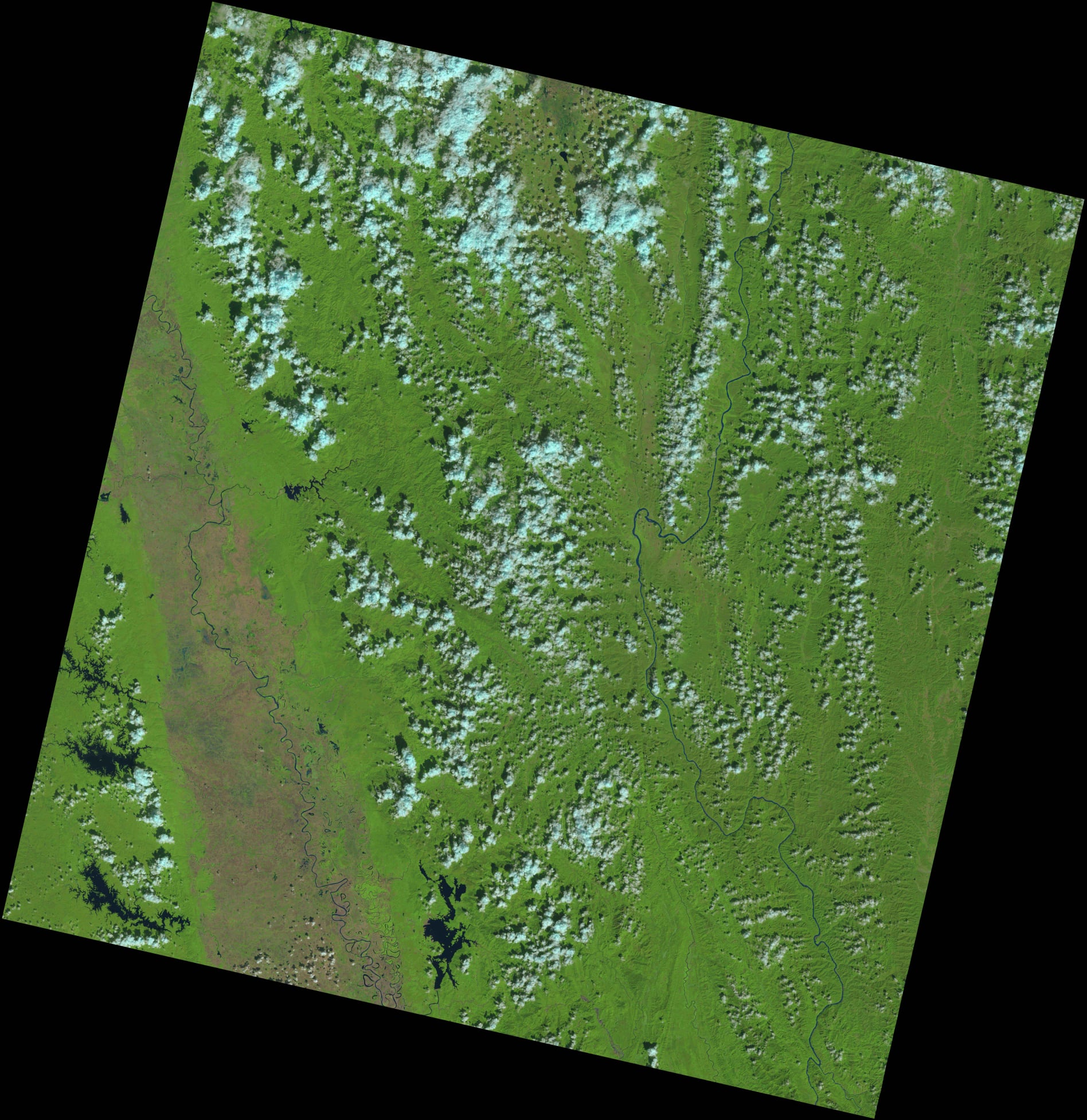
The first picture of Landsat9 taken in Thailand ?? will be taken on December 12, 2021 international time 03:55 a.m., WRS Path 132 and WRS Row at 047, taken in Thailand in Mae Hong Son Province. The Salween River border area is adjacent to Burma by Landsat9 with information and details as follows ??
Landsat Project History
The Landsat project has been around since 1972. Landsat satellite data has become an important resource for those working in agriculture, geology, forestry, regional planning, education, mapping and global climate change research. Landsat satellite images are also being used to manage major disasters. which supports emergency response and disaster relief to save lives. The launch of Landsat 9 satellites has completed half a century of terrestrial imaging in the Landsat project. And it is considered to be a weapon for researchers and geospatials around the world to have more modern and up-to-date tools and data. Today, I would like to penetrate the details of Landsat 9 only.
* In the history of Landsat project in depth The admin would like to explain in the next scoop. which will penetrate in detail, explaining each model from version 1-8
LANDSAT 9 data [3]
Landsat 9 is a collaboration between the National Aeronautics and Space Administration (NASA) and the U.S. Geological Survey (USGS), which will serve as a key player in the exploration and monitoring of natural resources around the world.
The Landsat 9, manufactured by Northrop Grumman using a version of Northrop Grumman Innovation Systems (formerly Orbital ATK), was launched by a United Launch Alliance Atlas V 401 rocket at a speed of 16,760 mph (26,972 km/h). that It is designed to last for 5 years and contains energy that can be used for up to 10 years.
Landsat 9 was launched into space on September 27, 2021 at 8:12 p.m. (GMT) from Vandenberg Air Force Base, Calif. on a United Launch Alliance Atlas V 401 rocket. Landsat 9 is equipped with an Operational Land Imager 2 (OLI) sensor. –2) built by Ball Aerospace & Technologies Corporation and a second generation thermal infrared sensor (TIRS–2) built at the NASA Goddard Space Flight Center, Maryland. The spacecraft was designed and built by Northrop Grumman. both sensors together
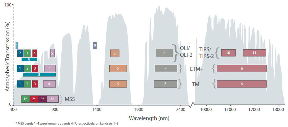
The sensors on the Landsat 9 satellite are an improvement over Landsat 8 (still in use today). There are two sensors, Operational Land Imager 2 (OLI-2) and Thermal Infrared Sensor 2 (TIRS-2). OLI-2 collects data on the Earth's surface in the wavelengths visible to the human eye. Infared, near-infrared, and The TIRS-2 measures the thermal infrared radiation or heat emitted by the Earth's surface.
Landsat 9's sensor improvements include a higher radiometric resolution for the OLI-2, up from 12 bits in Landsat 8 to 14bits. This allows the sensor to detect more detailed information. Especially in darker areas such as water or dense forests. With a higher radiometric resolution, 14bits Landsat 9 data can distinguish 16,384 shades of a given wavelength (Landsat 8 recognizes 4096 shades and Landsat 7 recognizes 256 shades). In addition to the OLI-2, the TIRS-2 also significantly reduces light interference compared to its predecessor, the Landsat 8 thermal infrared sensor (TIRS), which allows for atmospheric distortion correction. better correction and more accurate surface temperature measurement.
OLI-2 System Sensor
The design of the OLI-2 system is based entirely on Landsat 8's OLI system, which achieves the same image quality and spectral quality as Landsat8. Called the band (Band), the resolution of the pixel size or GSD (Ground Sampling Distance) is 30 meters for all wavelengths. Except for panchromatic image capture with pixel detail at 15 m and OLI-2 system. There is a calibration system inside the satellite to ensure the accuracy, precision and stability of all wavelengths. as well as the ability to calibrate the angle of impact of the sun and the moon. The details of the wavelengths in each band are as follows:
- Band 1 Visible (0.43 - 0.45 microns) Resolution 30 meters
- Band 2 Visible (0.450 - 0.51 microns) Resolution 30 meters
- Band 3 Visible (0.53 - 0.59 microns) Resolution 30 meters
- Band 4 Red (0.64 - 0.67 microns) Resolution 30 meters
- Band 5 Near-Infrared (0.85 - 0.88 microns) Resolution 30 meters
- Band 6 SWIR 1(1.57 - 1.65 micron) Resolution 30 meters
- Band 7 SWIR 2 (2.11 - 2.29 microns) Resolution 30 meters
- Band 8 Panchromatic (PAN) (0.50 - 0.68 microns), resolution 15 meters
- Band 9 Cirrus (1.36 - 1.38 microns) Resolution 30 meters
Thermal Infrared Sensor (TIRS-2)
Landsat 9's 2nd Generation Thermal Infrared Sensor (TIRS-2) measures the thermal radiation emitted by the soil surface in two bands of thermal infrared radiation. The design uses the same technology used. In the TIRS sensor on Landsat 8, the TIRS-2 is an upgrade from TIRS to the next level, both reducing the risk of equipment damage and designing to reduce glare spectrum interference. It is 100 meters on both bands and has built-in Blackbody calibration settings. The details of the two bands of the TIRS-2 system are as follows:
- Band 10 TIRS 1 (10.6 - 11.19 microns) Resolution 100 meters
- Band 11 TIRS 2 (11.5 - 12.51 microns) Resolution 100 meters
Source
[1] https://www.usgs.gov/.../usgs-opens-door-landsat-9-data
[2] https://earthexplorer.usgs.gov/
[3] https://www.usgs.gov/landsat-missions/landsat-9